Space Weather Prediction Center
Using this Map
Data Providers for the World Ionospheric foF2 Map (updated every 15minutes)
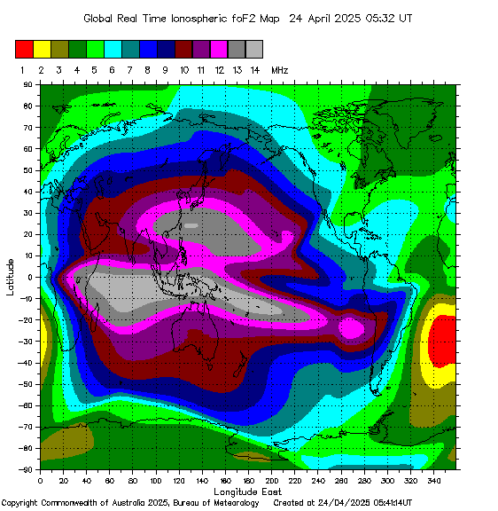
The data presented in this page are derived from the automated interpretation of ionograms from around the world. Regional data are obtained from the Space Weather Network (SWN), formely known as IPSNET, (Australia Pacific Region). Global data are obtained from the NICT Space Weather Information Centre of Japan (Japanese region), the Space Physics Group at Rhodes University's Hermanus Magnetic Observatory (South African region), the Istituto Nazionale di Geofisica e Vulcanolgia, Rome, Italy (Italian Region), the Facultad Regional Tucumn, Universidad Tecnolgica Nacional, Argentina, (South American Region), the Global Ionospheric Radio Observatory (GIRO), and the United States of America Space Weather Prediction Centre (SWPC). The ionospheric data available from the SWPC and GIRO are contributed by the International Space Environment Service's (ISES) Regional Warning Centres (RWCs) located around the globe, the United States Air Force (USAF) and several research institutes.
The yellow Sun symbol near the equator indicates the location where the Sun is directly overhead.
The regions of the world where the Sun is exactly rising or setting is known as the Grayline and is shown as the solid gray-colored line that is closest to the Sun symbol.
Near RealTime MUF World Map
Get the latest Maximum Usable Frequency MUF worldwide prediction updated
hourly.
![]()
Last Modified May 22, 2024